Veste Otzberg
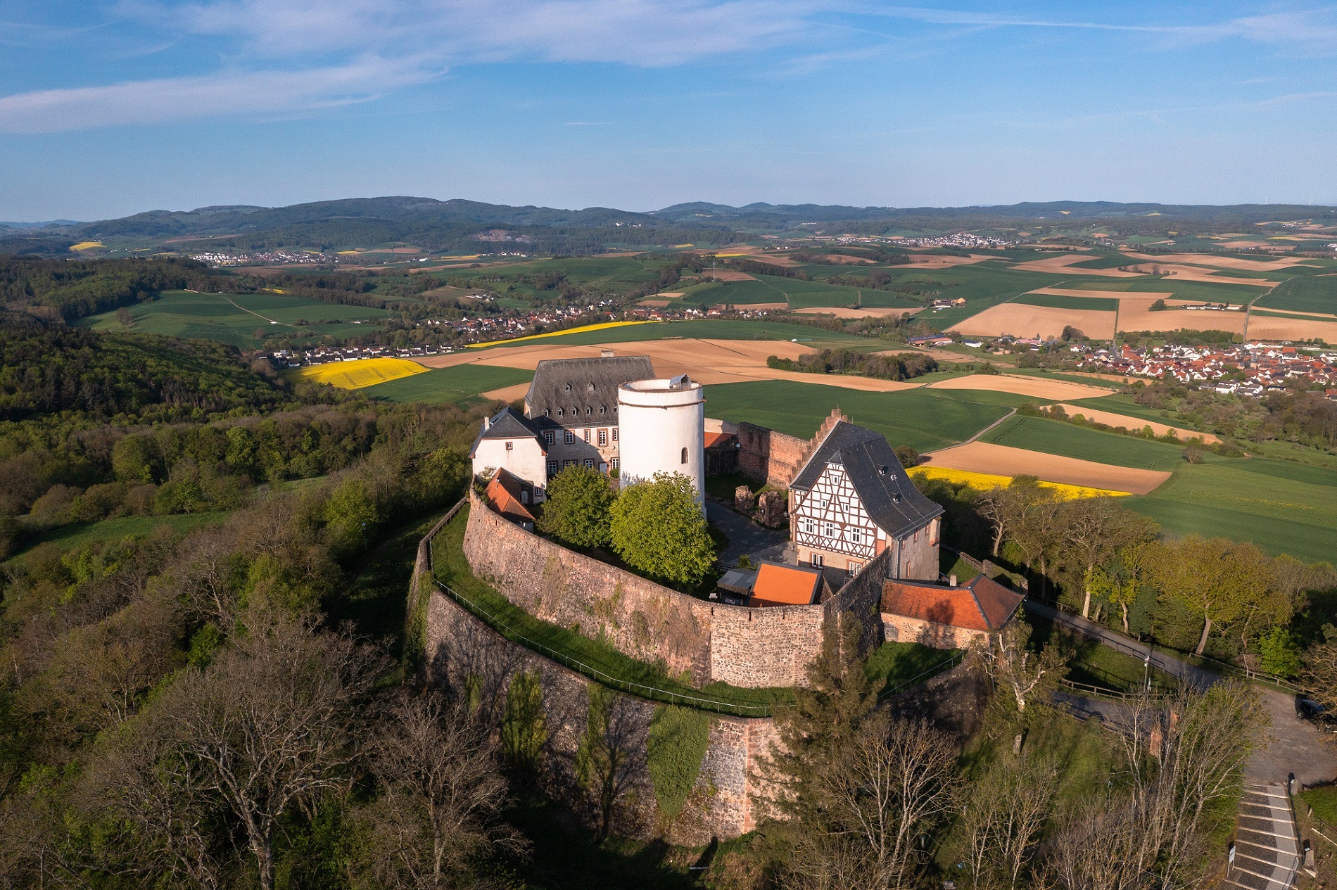
The hallmark of Veste Otzberg is its squat, lightly plastered keep. It is called the “White Turnip” in the vernacular. The basalt cone on which the former fortress is enthroned is clearly visible in the flat surrounding countryside. From the keep, on the other hand, the view extends all around to the Odenwald, Frankfurt and the Taunus.
History
Just under 25 kilometres southeast of Darmstadt, Veste Otzberg, first mentioned in a document in 1231, lies on a basalt cone in the Crystalline Odenwald. The oval ground plan of the building corresponds to the shape of the mountain. It was built after 1220 by the imperial abbey of Fulda, but changed hands several times in the following centuries. In the region, which was characterised by small and micro states, it also served the Count Palatine of the Rhine and the Counts of Hanau as a fortress to secure their power and possessions, depending on the ruling circumstances. The word “Veste” comes from the Middle High German term “veste” for “firm” and means nothing other than fortress.
Unlike castles, which were inhabited by the owner family, Otzberg was manned by Burgmannen, who were entrusted by the respective lordship with securing and defending the castle. By the beginning of the Thirty Years’ War in 1618, Veste Otzberg had been extended and expanded several times. The fortress could not withstand the siege by troops of the Catholic League, and its garrison capitulated in 1622. From 1803, the complex finally belonged to Hesse-Darmstadt, and its buildings served as barracks and a state prison. In 1826, many buildings were demolished and the fortress fell into disrepair.

The stout keep is the most prominent part of the complex and can be seen from far away. It is called the “White Turnip” in the vernacular.
- Foto: Stephan Peters, 2014

The keep dates back to the time of its construction. Behind it on the right is the commander’s house, where the fortress commander used to live.
Foto: Kilian Schönberger, 2016

The well ensured the supply of drinking water for the defenders even in times of siege. It is at least 50 metres deep.
- Foto: Stephan Peters, 2014

The fortress is situated on a high basalt cone and offers a great view over the surrounding Odenwald.
Foto: Kilian Schönberger, 2016
The Keep Bears the Name “White Turnip”
The most striking structure of the complex is its squat keep, which is 17 metres high and has a diameter of 10 metres. It tapers slightly towards the top. This shape and the light-coloured plastering earned it the popular name “White Turnip”. From its viewing platform, there is a magnificent view of the Darmstadt-Dieburg district; on clear days, you can see as far as Frankfurt and the Taunus mountains. Today, the keep is the only building that still dates back to the time when the fortress was built. It was surrounded by a circular wall, which was extended again and again. Somewhat younger is the well, which is at least 50 metres deep and dates back to the 14th century.
At the beginning of the 16th century, the inner wall was reinforced - a coat of arms of the Count Palatine of the Rhine on its northern side bears the date 1518. In the late 16th and early 17th century, the outer ring wall was built. Both walls are connected to each other by the gate building.

This wall remnant used to be part of the two-storey barracks. From the fortress walls, the view extends far into the landscape.
Foto: Stephan Peters, 2014
The buildings along the inner ring wall include the ruins of a two-storey barracks, the commander’s house from 1574, where the fortress commander lived. The house was originally a residential building and fruit store, so named because it also served as the workshop of a cooper who tied barrels together with willow rods. The still preserved cellar dates back to the 15th century.


